
North? What North?
The following is a gnostic lesson in how we check what we know, and try to avoid being confused by the same word meaning different things.
What do we mean by North, and the North Pole? These days, it's an internationally-agreed ISO standard, with a Geodetic Datum. That means an geo-engineered reference grid, so that everything is fixed and in an agreed place. Tidy like.
Geodetic datum standards (note the plural) matter in precise mapping and navigation, and agreeing where things are. But the wonderful thing about standards is that there's always more than one to choose from. For example, in living memory, the much venerated ye-olde-fashioned UK Admiralty paper charts used to use the OSGB(36) Datum. Since 1984, because of GPS, all new versions of the charts have been based on the WGS84 Datum, and all positions shifted slightly. And much wailing and gnashing of teeth there was from some reactionary olde-fashioned UK mariners who would rather go down with their paper charts and sextants than use some new-fangled invention like GPS. Or spend good money on new charts.
For example, South Foreland Lighthouse's geographical position:
51°08′39N 1°22′37E (on the OSGB(36) datum) 51°08′47N 1°22′35E (European (1950) datum) 51°08′42N 1°22′27E (WGS84)
If you were plotting a course to go past - and not straight into! - a lighthouse in poor visibility at night, those tiny differences could make a crucial difference. Especially with South Foreland Lighthouse, as it is on top of a cliff! Even if you are just an old salty Swedish sea dog on a foggy night.
More generally, it matters if you are navigating by GPS and using a marked location as a way-point. There are already urban myths (sorry, make that sailors' tales) of boats having head-on collisions at some frequently-used GPS way-points while the crews of both boats were dozing. Sigh - and all of that is with modern datums. Which are artificial constructions.
Go back 5,000, or 8,000 years, what did folk then use for datums? There was (and still is) a choice between two "natural" datums. The first was Solar, based on the position of the Sun at mid day (if you are sure when mid-day is), the second was Astronomical based on the position of the northern-most star, or the star that appeared to be almost stationary in the north. The second is fiddlier, but you can measure it any night of the year (British weather permitting).
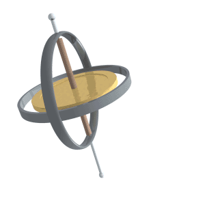
So far so good. But our ancient brethren went one step further, and discovered axial precession. Or, to give it its more poetic name, the Precession of the Equinoxes. This is due to a gyroscopic wobble of earth's spin axis that takes c.26,000 years to complete, on a scale of about plus or minus 1.3 degrees from the average value of 23.3 degrees. In the current cycle, the tilt reached a maximum of 24.2 degrees about 9,500 years ago, and has been decreasing ever since.
So, the "true" north Celestial Pole moves around through the stars.
Dragons in the North
At the moment, our northern-most star is Polaris. Five thousand years ago, it wasn't Polaris, it was Thuban, in the constellation Draco the Dragon.
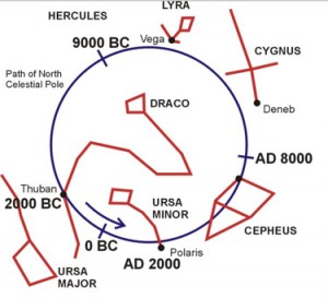
The traditional name Thuban is derived from the Arabic word ثعبان thuʿbān, 'large snake' (e.g. a python or a legendary draconian serpent). It is sometimes known as the Dragon's Tail https://en.wikipedia.org/wiki/Thuban
These dragons in the north all lived in the Purple Forbidden Enclosure.
Update, December 2020
I’m still on a steep learning curve, with a few false turns, so thanks very much for the patient feedback and explanations I've received.
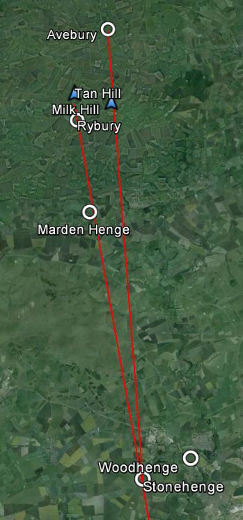
I had wondered if any attempts to "prove" there are alignments between places like Avebury and Stonehenge has to factor-in the age of the places, and where they were in the 26,000 year cycle at the time. Or, whether that gave us a way to date them from the variation in Axial Tilt. Assuming (a) the locations were first fixed in the current 26,000 year cycle and (b) that the megalithic builders were also very keen astronomers, and deliberately put the Avebury and Stonehenge areas on a precisely north-south meridian. As it was then.
I had wondered if, all being well, we can date the construction from when the axial tilt was last at that angle. Now, we could use Laskar's formula:
ε = 23° 26′ 21.448″ − 4680.93″ T − 1.55″ T2 + 1999.25″ T3 − 51.38″ T4 − 249.67″ T5 − 39.05″ T6 + 7.12″ T7 + 27.87″ T8 + 5.79″ T9 + 2.45″ T10
Or we could just look it up on a graph. Here's one they made earlier:
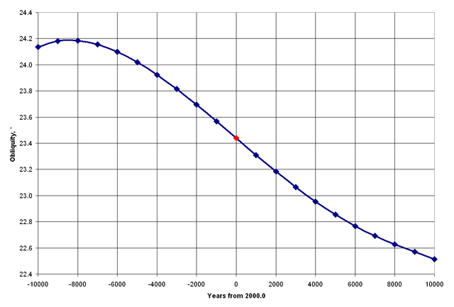
Unfortunately, I hadn't taken account of the daily rotation, which made a nonsense of the whole idea!
Footnotes
Footnote #1: On the quality of my map
Any complaints that this image doesn't look like a north-south alignment should be addressed to Google Earth. Please feel free to have an open mind and check it for yourself on an Ordnance Survey map, or here on OpenStreetMap.Footnote #2: Alignments
Afficianadoes of ley-lines will already have noticed that the line of sight from Stonehenge towards Avebury goes through Tan Hill, one of the two highest points in Wiltshire. The other line of sight from Stonehenge towards Marden Henge (the biggest forgotten henge in Britain) goes through Milk Hill, the other of the two highest points in Wiltshire. Why is that? Is it all a strange coincidence? I don't know. It's a mystery. Suggestions please...Footnote #3: Precession and Obliquity are easily confused. At least, I was confused. Here's one explanation:
Obliquity is about the angle of tilt of the Earth's axis relative to it's orbit round the Sun. This tilt gives us our seasons e.g. In June to August, the northern hemisphere leans towards the Sun giving us Summer. In December to February, the southern hemisphere tilts towards the Sun giving them their Summer. If you ignore all other effects, this tilt changes from 21.5 to 24.5 degrees over a 41000 years period. The more the angle, the more pronounced the seasons.
Ref : The difference between Obliquity and Precession
Did that make it more understanding? Well, I have to confess, I was still confused after reading that. What did help me was this video on Milankovitch cycles precession and obliquity. I hope it helps you too.
How changes in Earth's rotation can effect Earth's seasons and climate. Created by Sal Khan.
Ref : Khan Academy
Next : The Shining Ones